
Ladder Canyon to Rope Canyon Trail
- Jasmine Ayers
- Jun 24, 2021
- 4 min read

Updated: Jun 24, 2021
Length: 2.1 miles
Elevation Gain: 370 ft.
Route Type: Loop
Difficulty: moderate (All Trails)
Time: 2 1/2 hours
Parking/Fees: Free parking area with campsites available near trailhead.

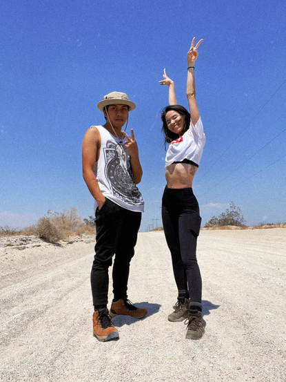
One of my best friends, who's also one of my travel buddies, will be leaving to Virginia for the Summer! Because of this, I wanted to go on a good hike with him before he leaves. The location that we decided on is in Mecca, California, called Ladder Canyon.
This trail is about 2.1 miles long and took about 2 1/2 hours to complete. Keep in mind, we did this hike mid June and the temperature was around 115 degrees Fahrenheit! We took a few breaks and even brought a towel to sit on while in the canyon for lunch. This being said, the hike could take less time than what it took us if you were to take fewer and shorter breaks.
The road to the trail head is very VERY bumpy. You'll need to go slow in order to avoid damaging your tires or shocks. This unpaved dirt road is about 3.5 to 4.5 miles long before you reach the trail head and I went between 10-15mph the entire way. I read articles and reviews to bring a 4WD vehicle because there are parts of the road where the sand is loose and you could get stuck. My car is a 2020 Honda Civic Sport Hatchback with front wheel drive. We were fine as long as we stayed on the main road. I tried to pull onto the side where there is a porta potty, but the sand was too loose and we almost got stuck. Please note, this trail is known to get flashfloods as well so make sure you research flashfloods in the area before you head out for your hike.
Things to know if you decide to hike here: If you decide to hike this trail, I highly suggest going during the cooler months. While in the slots of the canyon, the shade provided a cooler temperature, however, once you put a foot outside of the shade the sun will be unforgiving. This trail is very sandy so it's best to bring light-weight hiking boots and a lot of water. I brought my 32 oz. Simple Modern stainless steel tumbler and had to refill it once with an extra water bottle. You may need to bring extra water or a larger tumbler if you drink water excessively. I honestly LOVE the Simple Modern tumblers! They're half the price of Hydroflasks and work just as well. I have two so far, the 22 oz and 32 oz. They keep my water cold for hours and kept my water cold in the desert heat which was definitely needed. I've brought both along for camping and hikes alike and I've never had to go without icy cold water.

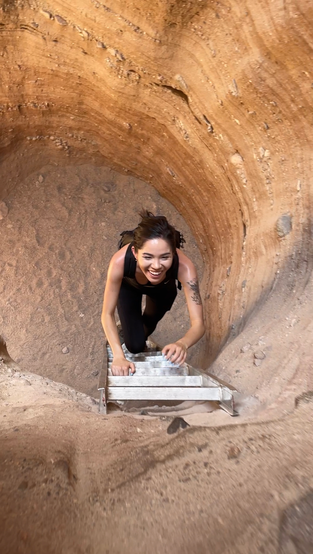
While on this hike, if you go the route that we took (see blue path in map above), there will be six ropes that you'll have to descend. We hiked this trail counter-clockwise which will have you going up a few ladders and down the ropes. If you go clockwise on this trail, you will go up the ropes and down the ladders. We did not have gloves since we were not expecting to go this route; however, gloves would've been beneficial for the ropes as well as having to touch hot rocks while climbing. Gloves are not absolutely necessary, but an extra comfort. I would also suggest to download the AllTrails app on your phone in order to view a map of your hike. There are many forks in the road and AllTrails helped guide us through when the direction we wanted to go was not always clear to the naked eye. For example, if you start on your hike the way we did, you would miss the first ladder opening. You have to climb up a few rocks and go underneath a small crevice in order to get to the first ladder. There IS a sign next to where you will find the beginning of the ladder trails (see below), BUUUTTTTT, it's on the other side of the rock! So unless you turn around you will not see this sign! Also, I noticed that going the direction that we did, arrows will be going the opposite direction. That does not mean that you are going the wrong way so please do not get discouraged. As stated before, download AllTrails onto your phone, it will save you time and confusion. Not only for this hike but any others you'd like to go on in the future. I've used AllTrails for most of my hiking and it has saved me from going off course many times.

The slots will get very narrow and there are some tight fits while going through the canyon. It's best to bring a smaller bag. My bag was 15 L X 14 W which was a pretty good size for this hike, but I wouldn't suggest anything larger.
It's also best to bring sunscreen if you're prone to getting sunburnt like I am. I used Coppertone Sport SPF 50 to help protect my skin from the sun's rays and I made sure to spray myself every 40 minutes just to make sure. I also wore my high waisted 90 Degree leggings instead of shorts to cover my legs from the sun; I had brought extra shorts just in case, but upon arriving at the trail I realized that even though it may be scolding out, it's best to keep my legs covered from the harsh UV rays.


Overall, this was a great hike and location! I wouldn't mind going a different route next time during a cooler season to explore a bit more. If you like to climb this is definitely a great hike for you! Until next time!


Comments